Showing posts with label walking. Show all posts

A Decidedly Damp Italy Part 2

We had one route in mind: the Nordkante on Piz Badile. A 1000m long line of immaculate granite.  It's the sort of route that gets people saying "the finest route in the Alps" and that sort of thing.

The only trouble was that it was raining.

Another trouble was that the route starts in Switzerland and finishes in Italy.  So while it rained we sat in the colourful Kandaluna cafe in San Martino in the Val de Mello and discussed logistics.  We stared at the guidebook. It was in German, so the staring didn't help that much.  We looked at the walk around to Switzerland. It was a long walk, had two high passes and might need crampons. We looked at the trip around via public transport. It looked like a ball-ache.

The next morning we woke up to sunshine and decided to hire a bouldering mat. According to a plaque, bouldering was invented here. It must be tricky to pin down when a climber first started training/messing around on boulders. We had a fun morning in a meadow by a river trying our hand at bouldering. The hard routes were too scary and hard. The easy routes were too scary and hard.  But we got used to the granite.

In the afternoon we decided to go and climb something proper. A four pitch route called Tunnel Diagonal. The hardest bit was finding it as our German guidebook had drawn a lake in the wrong place on a map. The climb was great and whet our appetites for more.

But the rain returned.

Rather than mope about in the rain we walked up to the Omio hut and spent the night there. It was a good move. Getting up high gave us a boost. This is what we'd come for: Mountains!

In the morning it was still raining. We had a leisurely breakfast, read our books, felt frustrated by the rain, and then walked down to the valley again.

After a night in a swanky mountaineering centre accommodation, we felt frustrated, so we walked back up. This time we took our climbing stuff and planned to stay in the Giannetti hut for a few days and see what we could get done.

We arrived in rain, had a beer in the hut, and then decided to go and look at the first pass on the route around to Switzerland.  Without our packs it was fun walking up to the gully and then tramping up the snow and climbing up the gap where the snow met the rock wall.  It was fairly precarious stuff without crampons but doable. The Swiss side , when we reached it, looked unpleasant.  Without crampons it would be a long, nerve-racking descent.  We went back for dinner. The forecast for the next day was reasonable. We decided to get up early and have a go at the descent route for the Nordkante. The Via Normale up the South ridge of Piz Badile.

In the morning it was windy but with clear skies. We stood outside in the wind. It really was windy.  We set off.  Getting off the ground was the most difficult route finding, but from there there was a set of abseil rings, painted arrows and red blobs to follow and we climbed the route quickly.  At the top the wind had disappeared and the cloud was gone. We had fantastic views across the Alps. Monte Disgrazia was especially impressive.  We had our lunch, took photos, had a look at the orange bivouac and saw people climbing the ridge.

We were a bit disappointed. Perhaps that should have been us. We'd missed our weather window.

We couldn't feel to bad because we were on top of an amazing mountain, with incredible scenery, in brilliant weather.  We set off down. It would have been easy to down climb the route, but we decided to get some practise of multi-pitch abseiling. This was surprisingly good fun and we were pretty satisfied with our improving slickness.  We were back down at the hut mid-morning and had a beer.

Two British mountain guides showed up a few hours later, they'd climbed the Nordkante and we chatted to them asking about the route and getting information for "next time".

The next day the rain, as predicted, returned. We set off for a walk over a pass to the Omio hut and then back down.

Again, weather had forced us to make a decision and we just hadn't felt confident to attempt the route while it was unsettled.  We made a good decision and when we go back, we know a lot more and will be well prepared.  We've got unfinished business.


A decidedly damp Italy Part 1

"Check mate."
Jo had beaten me at chess for the first time. She didn't look as smug as I might have thought.  We'd been killing time in the Refugio Tosa mountain hut all morning. It was still raining.

Two days before we had arrived in a baking hot thirty-three degrees Italy and been cooped up in public transport to get to Molveno. We immediately went for a swim in the gorgeous lake. We'd eaten a great big pizza sat in a touristy restaurant with nice views of the Brenta range and gone for a lakeside stroll.  Then there'd been a day of walking uphill. It started raining just as we stopped for lunch at a Refugio half way.  It had then rained solidly over night and all morning.

The hut warden told us that the forecast was for the weather to improve in the afternoon. So following a break in the weather after lunch, we set off for our first Via Ferrata of the holiday.

We were now in high mountains equipped mentally (lakeside memories) and physically (trainers on our feet) for the sun drenched Alps. Instead we got drenched. And a bit terrified.

Huge limestone towers loomed out of the mist we tottered along connected safely to the fixed cables of the via ferrata. The path way seemed to be gauged out of the side of the cliff. As we rounded a corner the cable disappeared through a patch of snow that lingered in a gully. The only way to continue was to unclip and walk across the hard snow, kicking steps as well as possible in trainers.  A rope would have been lovely, crampons and an axe even better.

After more ledges and ladders, more scary snow and with the rain now returned, we reached the Alimonta hut.  We met some blokes from Yorkshire who taught us a card game (called Bonk, a bit like 7 card Whist but you have to make a bid on how many tricks you'll win).

The next day the weather was improved and we did the Ferrata Sosat. With sunshine and scenery out in force this was a big improvement.  We reached Rif. Tuckett and had to make a decision.

The Brenta range is incredibly beautiful, but in the conditions we were finding them in, the via errata routes were much more of a serious, mountaineering effort than we were prepared for.  We decided to head down to the valley and get a bus to Riva del Garda.

Riva proved to be a good base for several via ferratas. One, which started directly opposite our B&B, took in fantastic views of the lake and the city below.  Being in the town also gave us far more flexibility with the weather.  So we swam in the lake, went to watch a gypsy jazz band and ate in an amazing restaurants.

On Jo's last day before getting a flight home, and starting work as a doctor, we hired a car and had a packed day.  We started on an unusual canyon via ferrata near Drenna. The route was formed by stemples that were bolted into the sculpted canyon walls.  The effect was a climb with lots of cool waterfalls and with some interesting strenuous overhanging bits that were really fun.  The route continued following the river, across some wobbly wire bridges up to Drena Castle.

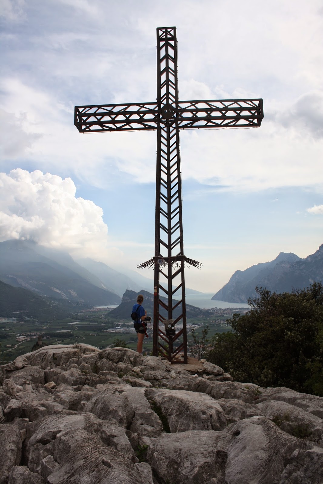
Back to the car, we realised we had loads of time to fit in another via ferrata. So we sped to Arco and set off up another one.  This was all a bit too easy but the views were terrific and at the top there was an incredible limestone pavement, a big iron cross and a fantastic view of Lago Garda.

Unfortunately there was also a great view of a big storm cloud coming our way accompanied with thunder and lightning.  Being stood by a big iron cross on the top of a mountain in a lightning storm didn't appeal so we descended quick.

Jo carefully explained that after a hot day, getting sweaty, climbing via ferratas, wouldn't it be a good idea to have a quick dip in the lake before we had to drive for hours? I knew she just wanted to go for one last swim.  All we saw of Torbole was the car park and the beach. We swam out, swam in, towelled off and got back in the car to drive to the airport.

We both were torn over that decision in the Tuckett hut, but it worked out well for us. Within a week we packed in two very different via ferrata holidays: a serene high mountain hut-to-hut walk and a lakeside luxury culture fest.

As Jo left, Conrad arrived.  And in the next week we had only one objective: Climb the Piz Badile.  Find out how we got on in Part 2.


Buttermere

PA310720
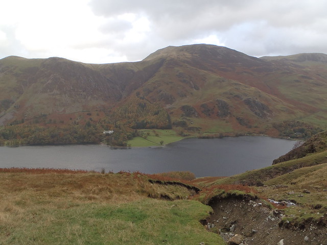
A month ago I'd never been to Buttermere. It's odd how without really planning it I ended up, on two separate occasions, driving over the Newlands Pass and parking up in this valley.  The trees are in full on autumn gorgeousness and this is a very beautiful place to visit.

Buttermere Trip One (31.10.13)
PA310732
Conrad and I parked at Gatesgarth and headed up to Grey Crag. I had great fun splashing through puddles and squelching through boggy bits.  Always fun but it was especially enjoyable as Conrad squirmed about trying to avoid getting his feet wet in his fancy approach shoes. I stayed smug and dry-footed in boots.

We selected Grey Crag on the basis that you could run together several easy multi-pitch routes.  The forecast looked like it might stay drier in the north. It had rained heavily the night before and everything was still a tad damp.

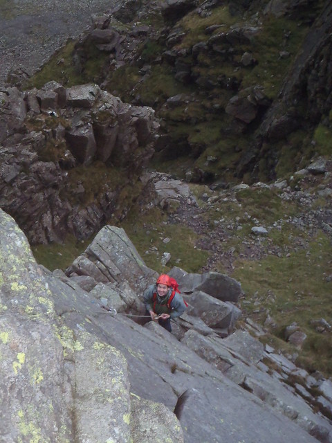
We climbed Harrow Buttress (Diff**) and then Slabs Ordinary (V Diff) and finally Oxford and Cambridge Direct (Severe***).  It was nice to have the slowly escalating difficulty and the quality of the routes improved each time.  As we went higher the routes dried out with O and C being exposed to plenty of wind.

We each had our scary moments (appropriate for Halloween). On the second pitch of Slabs Ordinary, Conrad climbed off around the corner for rather too many metres above the belay without finding any decent protection.

The scary moment for me came on the crux of the last pitch of O and C.  Conrad later commented that he watched me stop on the ledge and just look at the wall for a few seconds longer than is reassuring. I wasn't trying to put gear in. I wasn't trying out hand holds.  He decided that wasn't a good sign.  For me the slightly terrifying part was when I decided to take a peak on the right side of the arĂȘte and see if there were any holds around there. There weren't.  There was a long steep drop. And then there was a big gust of wind.

Somehow I got the bottle together to climb to the top and almost as soon as Conrad followed me up, it began to pour with rain.  We'd timed it perfectly. It would have been even scarier on that arĂȘte if there was a river flowing down it.

Buttermere Trip Two (16.11.13)
PB160744
Jamie and Laura have been collecting Wainwrights. I had a glimpse into their game with a great day's walking.

Like with Munro bagging, there is a list of the peaks written about in Wainwright's famous Lakeland guidebooks you can go about tramping up and down and ticking off. Jamie has a map with little red marks on the hills he's been up. There was a blank spot on a few just east of Crummock Water for us to get our teeth into.  First up was Whiteside.

It felt like a bit of a slog heading up that path so it was good to have a pause and hear about the flora.  Laura is a botanist and Jamie is a ranger.  Between them they know a fair bit about the small things growing around you on the hill and also about the big things growing down below.
"See those trees that look like conifers but their leaves have gone brown? Most of those are larch." says Jamie.
"All of those are larch," corrects Laura.

Down at our feet we spot some moss.  I incorrectly identify some sphagnum moss (the only one I've heard of) but it turns out it is Polytrichum.  While I'm forgetting how to say that we see some Club Moss, a Juniper tree (almost endangered - how are we going to make gin?!) and Geographica lichen (which looks like little continents).

We spotted an exciting rocky looking ridge from the slog and were pleasantly surprised to find it was an exciting rocky ridge as we walked along it to Hopegill Head and then down to a broad col where some boulders provided a sheltered picnic spot.


The walk continued over Grasmoor. The clag came down and we got the compass out and timed our pace as we followed a bearing.  9 minutes and 34 seconds later we found our path. It was 26 seconds early.  The visibility returned as we followed the ridge over Wandope and Whiteless Pike. Sadly there was no more need for the geeky navigation practise. 


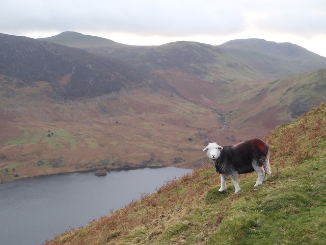
Unlike the Munros which are defined to be mountains over 3000 feet.  Wainwright just chose the big fells and the ones he liked. So we get Rannerdale Knotts to walk over even though it's a piddly 355m.  But it is well worth it. The views down the valley to Buttermere, with Haystacks and High Crag behind, are the best of the day. And the peak itself has the character of something much bigger with plenty of craggy bits and a few photogenic sheep.


Jamie tells me the sheep are Herdwick which is a Viking word meaning sheep pasture.  The "wick" bit can also be "vik" and it means bay or fjord. This is used a fair bit with place names like Wick and Lerwick and in the word "Viking" itself which means "one who comes from the fjords".  


I wondered about the red spray paint most of the sheep seem to have on them.  Laura reckons they put a load of ink on the chest of a ram. The ink comes off when the ram mates and the farmer can easily see which ewes have been shagged.
PB160747
I'm a convert to Buttermere, and I'd like to come back and try the ice cream. PB160748

I offer guided walks and walking holidays in Northumberland, the Pennines, the Lake District, Scotland and further afield.

I'm always keen for outdoor adventures to help people learn the skills to explore! My particular focus is mountain skills such as navigating with a map and compass and wild camping for expeditions.

Hiking Huayhuash


Donkey Daydreaming

Sometimes I wonder what donkeys are thinking. It's hard to tell. I was sitting by the side of the track on the Cordillera Huayhuash trek with Dave. We had just eaten our sandwiches and were sat enjoying the view. Towering peaks with elegant flutings of snow that, seemingly defying physics, cling to the near vertical slopes.

Up the track behind us came a line of donkeys and a Peruvian on a horse. The donkeys are used to carry all the equipment for the many tour groups that are continuously hiking around this trail. They didn't seem to have much enthusiam as they walked past. Thier backs were loaded up with tents, rucksacks, gas canisters, wooden crates, guitars, fold up seats and mountains of food. The tour group, some way behind, are left with nice light packs. The big donkey eyes gave away nothing on their expressionless faces.

The trek, which takes between eight to fourteen days, was recently voted the second most-beautiful trek in the world by National Geographic. It is located South of the Cordillera Blanca. Huaraz, the Peruvian equivalent of Chamonix, is a good place to base your stay in the region.

In some ways Dave and I had at least some idea how the donkeys felt. We didn't have the nice light packs and we didn't arrive in the camps with our food prepared and our tents errected. Instead we lugged ten days of food up each pass in heavy packs. We had an affinity to our four-legged friends. We had cleared the supermarket in Huaraz out of spaggheti and, on alternate nights, we looked forward to adding a tin of tuna.
Getting a good square meal...

One afternoon we arrived in the little village called Huayhuash. Well, village is a grand word for two adobe shacks and a dozen tents. We took off our rucksacks and rested against some rocks. The donkeys were being unloaded and, as far as we could tell, seemed to be enjoying it. Some of them ran about but most just munched grass.

'It would be very convinient if humans could eat grass wouldn't it?'
'I expect it would get boring after a while,' replied Dave, humouring me.
'Yes. Like pasta.'

We decided to try asking at one of the houses if we could buy dinner. Not only was the pasta diet getting tedious but we had quite limited amounts of both food and fuel. Happily, the farmer, in a rustic wide-brimmed hat, agreed and told us to come back at seven that night. When we arrived, the single room of the house was filled with smoke. It poured out of an adobe built wood stove which was being stoked with dried grass. We took our places on a bench with a sheepskin. The nicely laid table was lit with a candle in an old tin can. As the smoke cleared, we saw that a few women in tradditional dress were sat in the corner beside a wall. Alfondo, the farmer, brought us big bowls of soup. Big chunks of potato floated in the broth. Dave explained in basic spanish that his father was a potato farmer in Northern Ireland and he loves potatoes. Alfondo brought us another plate full. After making short work of the main course, rice and chicken, we wished the family good night. On our way out we were invited for breakfast the next morning.

Alfondo's mother was full of life in the morning and dancing to Quechua music playing from a small radio that hung off a rusty nail. She served us fresh homemade cheese with crusty bread which was washed down with warm milk. All from the cattle that grazed just outside in the massive valley. Once we had eaten our fill, Alfondo showed us the cheese-making equipment. Very basic stuff.

'This could be Ireland a hunded years ago,' said Dave.

Touching the Saftey Pins

Most of the campsites along the route have a squat toilet. These vary in design and quality but smell equallly revolting. Some are made with a few bits of timber and turf. Others have a solid block of concrete with a hole in the middle. Some are nicely built little things, others just a bit of tin with no door or roof. In one toilet the hole in the concrete was rather small and, in full squat, I had to do a little crab-shuffle to drop the bombs on target. They drop into an enormous void.

Joe Simpson, the acident-prone mountaineer and writer, was probably thinking of a different kind of void when he named his famous book Touching the Void. The mountain where he and his rope-cutting partner, Simon Yates, got into so much mischiff can be seen from Paso San Antonio.

We stayed an hour on the top of the pass admiring the view. SulĂ­a Grande, the cravase strewn glacier, the lake at the bottom. I went through the story from the book in my head trying to spot where the events occured.

The track down the other side of the pass was steep scree. Dave set off at a Kamakazee pace and I did my best to keep up. Then, perhaps inspired by Mr Simpson, Dave lost his footing and fell onto a rock with a yell of pain. He's broken a leg, I thought, and started to think how I would pull off an epic rescue. I felt in my pocket to check I had my penknife.

The graze ran the length of his shin interspersed with dull blue bruising but otherwise he was fine. His trousers were ripped at the knee. Savlon and saftey pins from Dave's first-aid kit sorted him out. Although, he did look like he had stolen his trousers from a seventies punk rocker.

We lost the track a little and followed directly down the valley which became a gorge. We teetered down loose black sand, and hopped between boulders. I saw Dave standing at the top of an overhanging waterfall. There was no way past. Fortunately we had no rope, so there would be no need for the penknife. Dave found a slippery grass ledge and cautiously made his way down past the waterfall. He said it was ok. Oh great. Now I have to do it too.

In the valley, we were able to hide our rucksacks behind some boulders. Then, unladen, we headed up to the lake for a superb view of the glacier and SulĂ­a Grande.

A Donkey's Dream

At the end of our trek we followed a narrow path into Llamac to wait for a bus back to Huaraz. We stood off the path to let some pack-donkeys past. I wondered if they had the same sense of satisfaction getting to the end of the walk. Did they have the same memories of indescribable beauty in their heads, somewhere inbetween those oversized ears. Probably not. They were probably going to be glad to have more grass to eat and less stuff on their backs. So, when I think about it, I am glad I am not a donkey.

El Calafate to El Chalten


After listening to a folk band in the campsite bar, and sampling (yet more) litres of Quilmes, our trusty pedal-powered hero woke fairly late and drank several cups of coffee and ate lots of toast and alfajor (yummy chocolate/ducle leche things). He then spent what seemed like an eternity trying to reorganise his panniers to be a) more convienient for commonly used items and b) with more weight at the front of the bike (who shall henceforth be known as Foxy Lady). Neither of these objectives were achieved and so the mission was abandoned in favour of cycling.
Weather was nice but reasonably windy. Lunch was ducle de leche and bananas on crackers and some turron.

Soon after Lago Argentina had slid behind a hill I came across a house in the middle of knowhere with "Bar" written on it. I headed in chased my barking dogs and it turned out to be a campsite too. So I gave in and ordered some food. On asking what he had on offer I was offered some piddling sandwiches and cakes, and then he offered a plate of beef steak. My eyes lit up and no more communication was required. Then dead cow was served with grated carrot and tomato and washed down by a black beer called Antares.

The next day was the sunniest and least windy day I have had yet so much so that my jacket stayed off all day and my arms got a touch of sunburn. I put in 120km to reach El Chalten just as it was getting dark. The whole day I was heading closer and closer to the mind boggling peaks of Mount Fitz Roy and Cerro Torre. I installed myself at the campsite and got a pizza. Disappointment ensued as I was unable to manage the entire pizza. The first time such a fate has befallen me. I think my stomach is getting smaller. Either that or it is the enormous quantity of cheese they use here.

Today the weather is much the same: balmy. I walked up to the Laguna Torre which is an excellent viewpoint for Cerro Torre, a crazily steep and magestic tower. I wore shorts (but long sleeves because of sun burned arms) and carried a very light pack with water, biscuits and not much else. Quite a relaxing walk through delightful countryside. I may have to stay here some time as my timing for the ferry to Villa O´Higgins is a little muddled. In fact I still can´t work out if it goes on Fridays or Saturdays such is the quality of the infomation. Well, tomorrow I plan to hike to the Mount Fitz Roy viewpoint and then we´ll see. If I miss the Friday/Saturday ferry there is one on Tuesday (or maybe its Wednesday). All a little confusing.

21 of the World´s Most Famous Walks


I´ve just finished a week trekking around Torres del Paine national Park in Chile. I had a fantastic time and its great to translate those photographs I had seen into actual memories. (This process is a bit like when I saw Chuck Berry play at Portsmouth Guildhall when I was 10 years old. It was my first gig and I went with my Dad. I was so excited because I had worn out my Chuck Berry tape by playing it a thousand times and was obsessed with him. Nothing compares to seeing the man in the flesh playing "Johnny B Goode".)

Anyway, I´ve been thinking about other treks for future holidays/expeditions. Here is my international wish list. Is one life long enough?

1. Torres del Paine circuit (Chile) (Pete has done it!!)
2. Los Glaciares (Argentina, options to veiw Cerro Torre and Mt Fitzroy)
3. Cordillera Real (Bolivia, 7 day circuit)
4. Bruce Trail (Canada)
5. Inca Trail (Peru)
6. Pacific Coast Trail (USA)
7. Continental Divide Trail (USA)
8. Appalachian Trail (USA)
9. Kerry Way (Ireland)
10. South West Coast Path (England)
11. West Highland Way (Scotland) (Pete has done it!!)
12. GR5 (Netherlands, Belgium, Luxombourg, France)
13. Snowman Trek (Bhutan,21 day hike in Himalayas)
14. Israel National Trail (er...Israel. 1000kms)
15. Everest Base Camp (Nepal, 18 days)
16. Annapurna Circuit (Nepal, 3 week loop)
17. Great Baikal Trail (Russia)
18. Nordkalottleden Trail (Finland, Sweden and Norway)
19. Grand Italian Trail (Italy, 6000kms)
20. Heysen Trail (Australia)
21. Milford Track (New Zealand)

Puerto Natales to Torres del Paine


Thanks everyone for the birthday messages. I had a lovely time at a mountain Refuggio quaffing wine, spining yarns, eating cottage pie with egg and cheese and sleeping like a log in my tent despite 70mph winds. The next morning I poked my head out of the flap at sunrise to see a reddish glow on the torres before going back to sleep with a hangover. I´ve now hiked most of the W route and am now considering making it into a loop. Cuernas and Torres were spectacular, tomorrow I hike up to the Grey Glacier. Loads of cool people on the trail. Brits, Yanks, Israilis, French, Belgium, Spanish, Swedish to name but a few. Good for company and conversation.
Route from Puerto Natales to Torres del Paine national park was a bit windy and a gravel road most of the way. Met a switz guy who cycled from Alaska at a cafe in Cero Castillo.
Bad news is my camera screen broke and I now have no idea what will happen. Nevertheless, I still take photos blindly and hope for the best. I think I will buy on in Calafate as a birthday pressie.
Also, sorry to anyone who got a spam e-mail. Don´t know what that is about.

Oss and Dubhchraig


Coille Coire Chuilc is a great bit of woodland filled with gnarly pines, part of the ancient Caledonina Forest. Its also very muddy. If you get through all the bogs with both boots still attached to your feet you'll end up on the grassy slopes of Beinn Dubhchraig. From the summit there were great views of the Crainlarich Hills (I was climbing last weekend). As I walked round to, the bit taller, Ben Oss, there is a fantastic view of the most stunning mountain in the area, Ben Lui (or if you are a gallic fan Ben Laoigh).
Cool trees
Summit cairn of Ben Oss and the magnificent Ben Lui

Theres no such thing as bad weather. . .


... just the wrong clothes.
The only patch of blue sky all day

Six other attempts are just photos of cloud

The forecast said it was going to be a wet, windy and cloudy day. Looking out the window confirmed it. Nevertheless I got out of bed and drove to Crainlarich, got into my waterproofs and slogged up Beinn Chabhair. With a bit of trickyish navigation I dropped down to a bealach and then up to Beinn a Chroin and An Caisteal and back to the car along the twisted hill. It was a windy, wet and cold day but I was dressed for it and, perked up by a flask of coffee and some mars bars, I enjoyed being out amongst it.

Highland Cross


Letting the other CAACers disappear ahead of me, I took the first four and a half miles at a gentle pace. Then, after crossing a bridge, there was a steep climb. Feeling strong, I kept a steady jog up the hill and took satisfaction in overtaking several people walking including David Law. On a narrow path near the top there was a dramatic waterfall and then the ground levelled. For the next few miles, as far as the Camban Bothy, the ground was undulating and I still felt good and kept up the pace overtaking Dave Henderson.

On flatter and stonier ground I started to get a bit of pain in my knee which checked my pace. In fact I took it easy all the way across the river, past the Youth Hostel and as far as the "Fire Ladies Welcome". (The race was originally devised for firemen and their wives would meet them here.) I wasn't at all tempted by the spread of sandwiches and cakes, but the ambulance truck looked comfortable!

Shaking thoughts of quitting I headed up the notorious Yellow Brick Road. To clear things up, its not yellow, there are no bricks and calling it a road would be a generous lie. What it is is a hard stony track at a steady incline for the length of Loch Affric. I struggled on.

The track continued and eventually became a paved road. I found it harsh to run on this surface and had to walk a few sections. Soon the transition appeared. A kindly bespectacled old local handed me my bike and I changed into my cycle shorts and scoffed a banana. Then I was off to whizz down hill at electrifying near-F1 speeds.

Well not quite. After I had gone a few hundred metres I realised the rear tyre was a bit soft. I stopped, pumped some air in and continued. After a while I heard a clanging sound of metal on road. I stopped again and realised there was a split in the side of the tyre. The tyre must have been damaged when being transported from Inverness. I popped off the wheel and stuck a few patches on the inner tube but there was nothing much I could do to repair the tyre. Fortunately a reasonable amount of air stayed in the Tyre and I managed to get to the end by stopping every quarter of an hour or so to pump it up. A little frustrating but I was just glad to get back to Beauly where a bed, bath, shower, dinner and beer were patiently waiting for me.

It was my third visit to Glen Affric in four weeks. I was there a month ago munro bagging with Alastair, then I was back for the LAMM two weeks ago.

On Sunday, to loosen up the legs, Dave and I headed up a couple of munros in Glen Affirc called Toll Creagach and Tom a'Choinich. We dropped the Tom one along a ridge that looked a bit steep from a distance. Reassured by a dog walker that there was a good path, we followed it and it were glad we did.

Ridges in Glen Shiel


Having spent four days cycling the coast to coast route, and then driving up to Edinburgh, Alastair sat at my dining room table and looked at the map. It was an ambitious plan.

We arrived at Cluanie Inn at about midnight and found some woods to stash a load of food, then we continued towards Shiel Bridge. Finding a lay-by we laid out our mats and sleeping bags in the back of the VW people carrier (seats removed) and slept like logs.

Wednesday began with porridge, tea and rain showers. We set off up Meallan Odhar and then on to the Forcan Ridge. Despite the continuing showers we scrambled along the crest, resisting the temptation of the path on the right hand side which avoided the difficulties. Only when we reached a steep down climb did we opt for a steep muddy gully instead. With a few more short sections of scrambling on the route we topped The Saddle and dropped down into Bealach Coire Mhaligain and then walked up the path to Munro number two: Sgurr na Sgine.
My poor map reading was to blame for a choice to go down of this peak via a dodgy NW ridge, whilst the GPS wanted us to go over the edge of a vertical cliff. The prudent choice in hindsight is to head south at first and then cut back to the bealach.

Four peaks later (and only two Munros), E along the South Glen Shiel, we passed Sgurr an Lochainn and looked at the lochan. It looked a bit far down. Seeming a waste to loose any height unnecessarily we looked for a spot of flat ground for a campsite. This proved difficult and led us to drop towards the lochan. We eventually found a precarious spot that was not too boggy and got in the tent just in time to avoid another shower. We cooked up some cous cous and some bush tea and were asleep by 8:30pm.
We woke on Thursday to rain on the flysheet, we ate maltloaf and waited. When the deluge turned to drizzle and then petered out, I brewed up another bush tea and we packed up the soggy tent and got going. With little respite from the rain we headed east and bagged munros. At the last, Creag Mhaim, the sun popped out for a moment or two. We dropped down a track and followed it to Cluanie Inn.

At this point our plan had been to take on the Chralaig-Mullach ridge, stay at the Camban Bothy and then hike back to the car via some of the hills on the north of Glen Shiel. Disillusioned by the weather, fatigue but mostly, I suspect, the fact that we had forgot to stash the wine, Alastair hitched back to fetch the car. We regrouped, got a coffee in the Inn, found the stash, ditched the wet tent, packed two bottles of wine and set off along the track on An Caorann Mor. The track became path and the path faded out into a bog. We hopped over the river on stepping stones and contoured on drier ground on the side of Ciste Dubh. Spotting the bothy in the vast glen where three large burns converge to form the River Affric, we headed back into the bog and looked doubtfully at our next river crossing. There was nothing else for it, boots and socks had to come off and we waded across barefoot. Sadly there was no fuel supply at the bothy, and vain attempts to light a few lumps of charcoal with the gas stove didn't manage to dry out my socks. The bothy was warm enough anyway and the best accommodation yet. We drank wine, ate noodles, custard and bananas and slept.
Friday started in a familar manner, rain. We tidied the bothy a bit, made porridge, drank tea and headed along the track towards the youth hostel. At some point we decided to veer off across a bog. We then had to recross the river. Al got his feet wet again but, with a few lucky leaps, I managed to hop across a couple of boulders. Then we came across a few bits of metal. Then we came across a few more. Then we came across a crash site. (Later uncle google didn't disappoint).
The ridge from Mullach to A Cralaig was much better than I was expecting, and so was the weather. The sun came out and my jacket, and then my fleece went in the sack. Being on the hill in a t-shirt doesn't happen too often and I was happy to get a touch of sunburn too!